One question: How much vegetation will be lost?
THE devil, they say, is in the detail. And in the case of the Bass Coast Shire Council’s proposed “Inland Route” for a 14-kilometre shared pathway between Inverloch and Wonthaggi, it’s in the unpublished detail.

THE devil, they say, is in the detail.
And in the case of the Bass Coast Shire Council’s proposed “Inland Route” for a 14-kilometre shared pathway between Inverloch and Wonthaggi, it’s in the unpublished detail.
Last week, on Thursday, January 27, when Bass MP Jordan Crugnale announced that the State Government was committing $3 million from its Growing Suburbs Fund to make it a $7.7 million project, there was precious little detail contained in a shire media release to support the announcement.
“This project will have fantastic economic, social and recreational outcomes for residents and visitors to Bass Coast,” gushed the Mayor Cr Michael Whelan at the time.
According to the shire’s statement: “Council has allocated $4.7 million to complete the Wonthaggi to Inverloch trail, which will be constructed between 2023 and 2025, following unused road reserves throughout farmland, taking in spectacular coastal and rural views.”
But it's substantially an incorrect and potentially misleading statement.
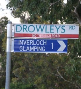
“...taking in spectacular coastal views…” is a misleading and confusing statement, indicating the trail will follow the coast between Inverloch and Wonthaggi, a core aim of the Yallock-Bulluk Marine and Coastal Park Draft Access Infrastructure Plan, but not associated with the shire’s own project. In fact, the only “spectacular coastal views” available on the “Inland Route” are the glimpses of the Inverloch and Venus Bay beaches you’ll see going up and down the first 800-metre section of Drowleys Road, just out of Inverloch. And that's assuming you survive a dangerous bend in Toorak Road to get there. The rest of the proposed route goes across, by the landowners’ own admission, “fairly uninteresting farmland”, coming out into the industrial area of Wonthaggi at Carneys Road.
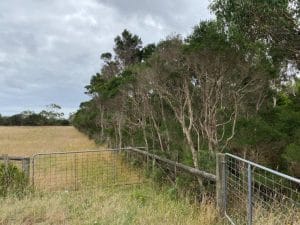
“…following unused road reserves throughout farmland…” could be regarded as a misleading statement also especially when combined with the route map in the ‘Bass Coast Shire Aspirational Network Pathways Plan 2016’, the basic map provided in the shire’s meeting agenda of September 15, 2021 and the latest ‘draft’ route map, supplied days after last week’s announcement. All of these maps indicate that the path will utilize the existing road network and so-called “unused road reserves”. What the shire doesn’t say is that a new pathway, a 1.5m to 2m wide sandy gravel strip, will be cut through the roadside vegetation beside the existing roadways, along Drowleys, Emma, Martyn, Boundary, Moores and Carneys roads, as well as through the middle of these “unused road reserves” which in most cases include dozens of hectares of significant and remnant bushland, home to koalas, lace monitors and all manner of wildlife (it has been reported).
According to affected and adjoining landowners, a significant amount of bushland will be lost when the proposed “Inland Route” is constructed, far more than what will be lost on a genuine coastal route.
It’s a fair question to ask, they say; “How much?”
There are a lot more questions besides.
Such as, will $7.7 million now be enough to construct the full length of the “Inland Route” after new engineering requirements for the trail, including two cattle overpasses, boardwalks over wetlands, carparks and all the rest, have apparently blowout as a result of recent consultation with affected landowners?
Also, how does the establishment of the “Inland Route” affect the likelihood of the more popular and significant “walking and cycling” route around the coast road, between Inverloch and Cape Paterson, going ahead?
Where is the Business Plan, the Environmental Effects Statement, the Economic Impact Statement – what for example will the economic cost be to Cape Paterson if the “Inland Route” kills any chance of there being a coastal path anytime soon? What is the estimate of how many people will use the Inland Route as compared to the coastal route past the Flat Rocks dinosaur site, Eagles Nest, Twin Reefs and the truly world-class, truly spectacular Inverloch-Cape route?
Even when the Council made its decision on September 15, 2021, very little of this detail was presented and certainly not discussed at the height of the COVID-19 pandemic. They voted: “That Council authorise a submission to the current round of the Growing Suburbs Fund for the Inverloch to Wonthaggi Trail Project ($3 million) and allocate $4.7 million towards the project”.
So, is the “Inland Route” a good idea?
Would any volume of lost vegetation, lost native habitat make a difference?
Would it be better to throw the $7.7 million in with the $19.6 million already committed to implementing the recommendations of the Yallock-Bulluk Marine and Coastal Park Draft Access Infrastructure Plan, of which a coastal pathway is a core objective?
Or should we simply shut up and take the money – accept that any safe cycling and walking route between Inverloch and Wonthaggi is a good thing and that the development of a coastal route between Cape Paterson and Inverloch was always going to be unlikely?