Some questions answered on $7.7m ‘Inland’ path
WHEN Bass MP Jordan Crugnale surprised the Bass Coast Shire Council, on Thursday, January 27, with the announcement of a grant of $3 million towards the Inverloch-Wonthaggi path from the Victorian Government's Growing Suburbs Fund, there remained many unanswered questions.

WHEN Bass MP Jordan Crugnale surprised the Bass Coast Shire Council, on Thursday, January 27, with the announcement of a grant of $3 million towards the Inverloch-Wonthaggi path from the Victorian Government's Growing Suburbs Fund, there remained many unanswered questions.
The shire didn’t have any supportive information ready to go.
Now, after days of questions and conjecture in the papers and on social media, the shire published a paper, after close of business on Friday, February 11, where some of the background information has been released.
But questions still remain about the amount of vegetation that will be lost to make way for the trail, especially how mature habitat trees will be replaced in a proposed offset program.
The are also no specific details on how many people are likely to use the Wonthaggi-Inverloch inland route or the final cost.
You’ll find what the shire has released to date at: https://www.basscoast.vic.gov.au/services/projects/wonthaggi-inverloch-shared-pathway
Why aren't we building a coastal path?
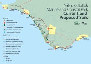
Council is fully supportive of the Yallock-Bulluk Marine and Coastal Park, the Plan which refers to a new proposed shared use trail along Cape Paterson–Inverloch Road. But due to the ongoing Coastal Hazard Assessent and other significant planning challenges, unfortunately a short-term solution for this route is not possible.
What is the strategic basis for the ‘Inland’ path?
The alignment of the Wonthaggi-Inverloch Shared Path originates from Bass Coast’s Aspirational Network Pathways Plan which was created as a result of community workshops held in 2015 and was adopted by Council in 2016. The alignment was also highlighted as a future project during the development consultation for the Active Bass Coast Plan. The community consultation on the Yallock-Bulluk Coastal and Marine Park also highlighted the overland alignment as a future cycling link on all draft plans and the final plan. The Gippsland Destination Management Plan also includes this overland alignment as a vital link in the Gippsland Trails Odyssey, the plan for which went through significant public consultation.
What about vegetation removal?
A vegetation assessment and arborist report have been undertaken to assist in the design. (If so, where is it? Councillors claim they didn’t see the report before making their decision to go after the grant in September 2021).
What are the economic benefits? How many people will use the path?
Despite its $7.7 million price tag, there has been no economic impact or business case prepared specifically for this project. The shire has cobbled together information from reports that may be relevant to the Wonthaggi-Inverloch inland route as follows: The REMPLAN Impact Summary Report identified this project will create 31 jobs and generate $14.54 million in direct economic benefit to the region. Extensions to the Great Southern Rail Trail and Bass Coast Rail Trail indicate a sound investment of capital from a regional perspective, with cost-benefit analysis on these projects, estimating that $1.28 in benefits will be generated for every dollar invested on the project.
On completion of the proposed Gippsland Odyssey (of which either the coastal route or inland route would be a part), visitation is projected at 123,600 in Year 1 to around 227,000 in year 10 (across the proposed 270km). How relevant that number is to the Wonthaggi-Inverloch pathway is not explained.
Where does the pathway start in Inverloch?
The proposed alignment begins at the Inverloch Surf Life Saving Club and follows the pathway on Goroke Street. It then crosses Toorak Road to Drowleys Road, which it follows inland towards Wonthaggi.
Were adjacent landholders consulted?
This path is to be constructed on public land, being unused road reserves that were set aside for transport purposes, including pathways. Adjacent landowners to the proposed path alignment have been consulted with since the feasibility studies began in 2017. Infrastructure such as cattle underpasses and fencing will be provided so that farming operations can continue.
Will there be toilets on the path?
Short answer ‘no’. Path users can currently access toilet facilities at the Wonthaggi Centennial Centre or the Inverloch Surf Life Saving Club. Toilet facilities were considered in the initial planning stages of the path however, it was decided that the anticipated usage of the path did not warrant toilet facilities to be constructed in between Wonthaggi and Inverloch.
Here are a few other points:
- January 27, 2022, Victorian Government provides $3 million from its Growing Suburbs Fund.
- The remainder of the $7.7 million project is being funded by Council ($4.7 million) although the construction plan has not been completed nor final costings submitted.
- The council did not have an environmental report, economic impact statement or business case (how many will use the trail, final cost etc) in front of them when they made their decision to support the $7.7 million project on September 15, 2021.
- The Wonthaggi to Inverloch path alignment originates from Bass Coast’s Aspirational Network Pathways Plan (includes 52 other aspirational pathways) adopted by Council in 2015 from community workshops in 2015.
- The shire says it first consulted with adjoining landowners in 2017, but some say it was presented to them as a done-deal in 2018, and more recently they’ve been consulted again at the beginning of detailed design including cattle underpasses “provided so that they can continue their operations”.
- Council claim: The majority of the path will run through Council-owned road reserves and already cleared areas where no vegetation removal is required.
- Council claim: Where the path does run through existing vegetation, an avoid and minimise principal has been applied to minimise the amount of vegetation being removed. A vegetation assessment and arborist report have been undertaken to assist in the design. Any vegetation removal that takes place will be offset as per state government requirements and additional native vegetation planting will take place where the path runs through cleared farmland.”
- Council claim: Although it is an inland route, there are still attractions along the way such as wetlands and native vegetation which provide habitat to wildlife.
- Shire is “currently in the detailed design phase and are meeting our funding requirements.