

No inundation threat but 13% of Inverloch’s houses still at risk
MUCH of the heat generated by the Cape-to-Cape Resilience Plan process has been about assessing the risk to houses in Inverloch, however, while high tides and storm surges represent some threat there is effectively no risk at all of permanent inundation by the sea in the foreseeable future.

MUCH of the heat generated by the Cape-to-Cape Resilience Plan process has been about assessing the risk to houses in Inverloch.
And whether or not sufficient protection is being proposed to address that risk.
However, according to the final report released just before Christmas, while high tides and storm surges represent some threat now, and into the future, there is effectively no risk at all of permanent inundation by the sea to homes in the foreseeable future.
According to the report, storms combined with high tides already represent a threat to 13 per cent of the land and homes in the town’s general residential zone, rising to 14% in 15 years’ time and 15% by 2070.
But the threat from erosion and permanent inundation is almost negligible.
The report says the risk from inundation is less than 1% now and does not rise above 1% through until 2100. And while there’s no risk to houses from erosion of the dune system now, and only to 3% of the town’s residential land by 2040, 11 per cent of the residential area could be at risk from the steady march of erosion of the coast by 2070.
The exceptions are the Inverloch Surf Lifesaving Club, some roads including Cape Paterson-Inverloch Road (Bunurong Road) and Surf Parade and the town’s utilities.
“Each of Inverloch’s different utility networks - drainage, drinking water, electricity, gas, sewerage and telecommunication infrastructure - have some level of coastal hazard risk under present day conditions,” according to the report,” from the Cape-to-Cape final report.
“Critical infrastructure at increasing risk includes major sewer and gas lines, and several sewerage pump stations. Sea level rise may also reduce functionality of some networks, such as drainage.”
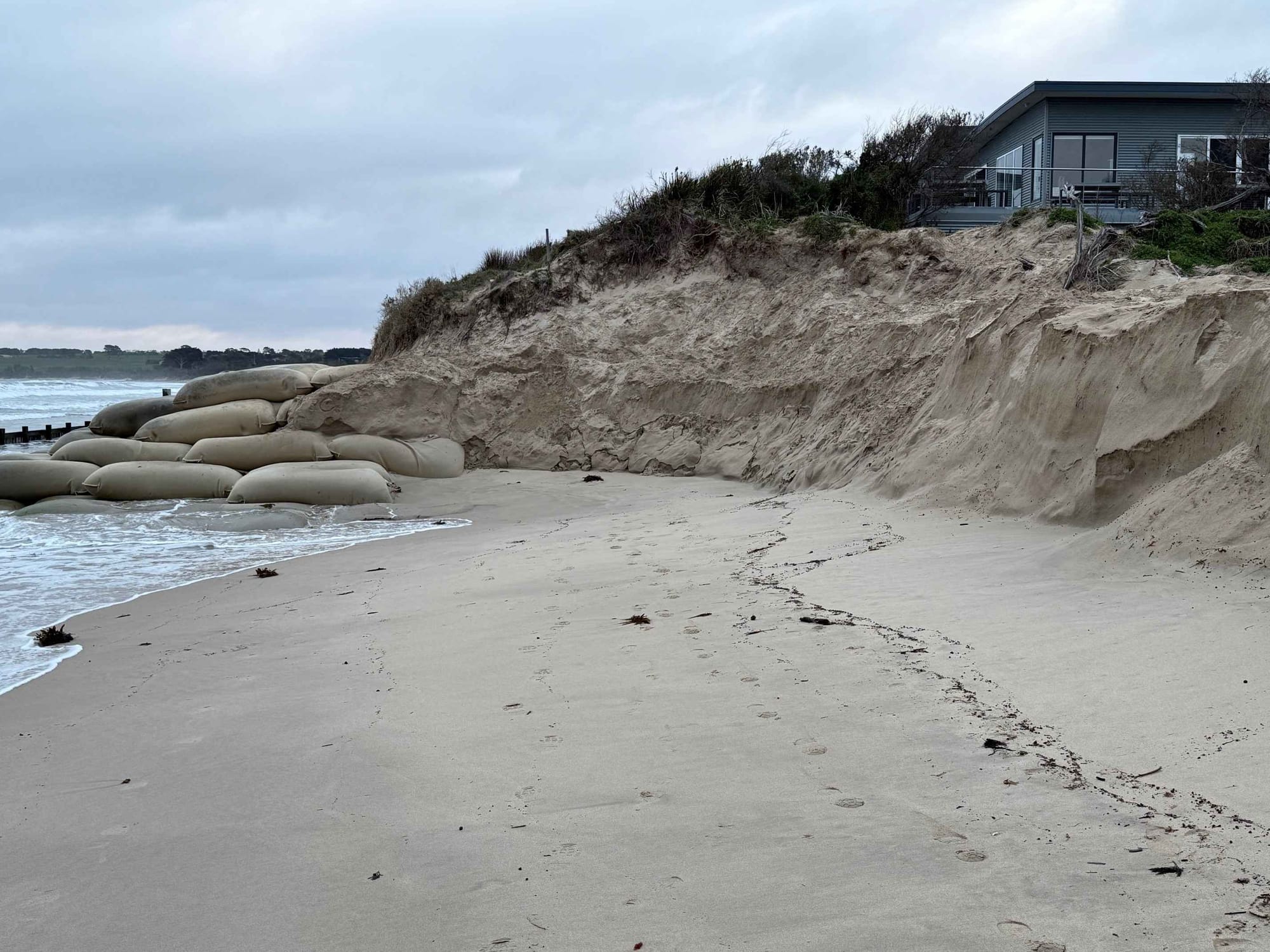
But it’s the surf club that’s in the firing line right now.
“A key facility for Inverloch, the Surf Life Saving Club, is increasingly at risk of erosion, reaching significant risk when 0.2m SLR (sea level rise) is realised (2040 onwards). Other key coastal facilities such as the region’s boat ramps are at increasing risk, with decreasing function over time with sea level rise.”
So, the risk to a small part of Inverloch’s residential area (13%) is mainly coming from storm surge combined with high tides and much later from erosion, not inundation.
But, after five years of study, what does the Inverloch RaSP committee of eight agencies, including the Energy, Environment and Climate Action (DEECA), propose to do about that storm surge/high tide problem and others identified around Inverloch and further along the coast into South Gippsland in its 91-page final report?
It's not at all clear.
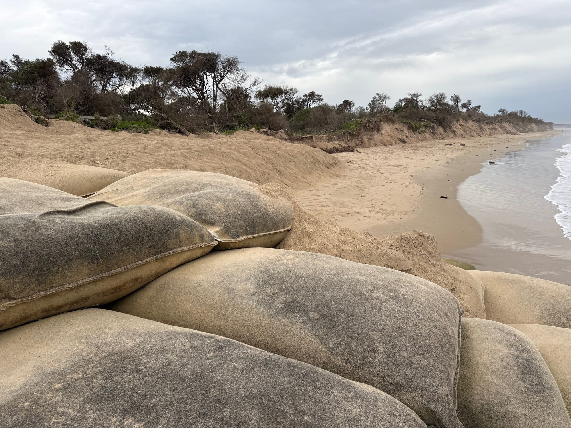
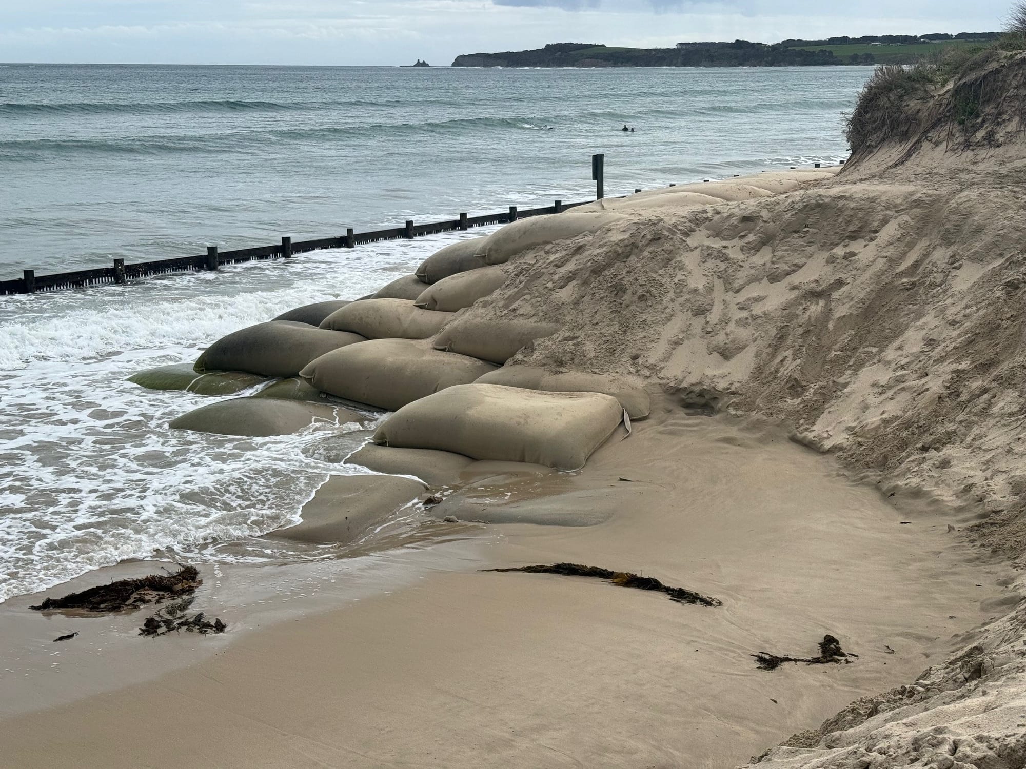
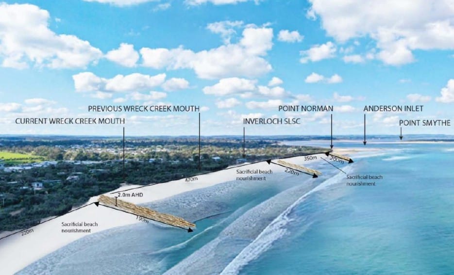
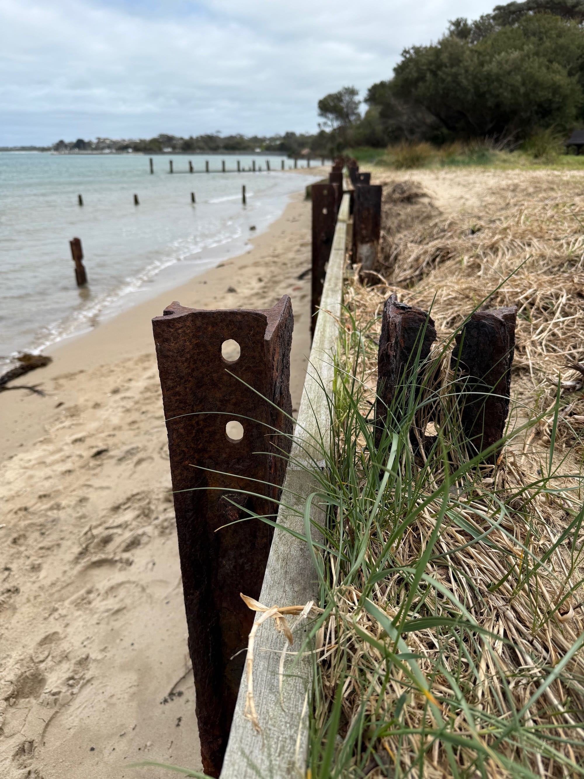
Beyond providing the basis for the $700,000 extension and remediation of the geotextile sand-bag wall in front of the Inverloch Surf Lifesaving Club (partly completed) and the large-scale dune nourishment and revegetation works, featuring the movement of between 100,000m3 and 150,000m3 of sand, set to start in February next year, there are no recommendations about work or structures that will protect homes from storm surge and high-tide damage.
That still falls back on government, and the local community, which must somehow make sense of a convoluted report that lacks clear recommendations for action.
“Detailed decisions about the implementation and timing of actions will be made in line with the normal government policy and budget processes,” according to the report.
Five ‘pathways’ have been examined for a range of location-specific actions at the Inverloch Surf Beach including:
- Pathway 1: Nature-based small-scale dune nourishment, moving to transition of built assets over time, including Inverloch Surf Lifesaving Club, Surf Parade infrastructure and residents.
- Pathway 2: Nature-based small-scale dune nourishment, moving to protection with larger scale sand renourishment, and then transition of built assets over time, including Inverloch Surf Lifesaving Club, Surf Parade infrastructure and residents.
- Pathway 3: Nature-based small-scale dune nourishment, moving to protection with larger scale sand renourishment and structures (e.g. groynes), transitioning to protection with hard protection (e.g. seawall), with no beach.
- Pathway 4: Nature-based small-scale dune nourishment, moving to protection with larger scale sand renourishment, moving to protection with hard protection (e.g. seawall), with no beach.
- Pathway 5: Nature-based small-scale dune nourishment, moving to protection with larger scale sand renourishment, moving to a combination of transition and protection (e.g. structures).
All pathways include planning to avoid current and future risk, some nature-based dune and vegetation enhancement, and accommodating risk through utilities, drainage and building upgrades.
Preferred pathways
The preferred pathway at the Inverloch Surf Beach is Pathway 5 for the following reasons:
- Provides good alignment with community values through retaining beach and natural amenity.
- Retains the valued sandy beach in a more natural state for longer, supporting tourism, local economy and the value of the beach.
- Allows existing built assets and properties to be retained in current locations for a bit longer (but not indefinitely)
- Aligns with the Marine and Coastal Policy through supporting transition options where possible for this location, before ‘protect’ options.
- Retains broader public benefit (the beach).
The preferred pathway initially for Cape Paterson Inverloch Road involves the following:
- Planning and development controls including consideration of longer-term access
- Targeted dune and vegetation enhancement to improve the natural dynamics of the dune system, and provide hazard buffer
- Accommodation of risk through infrastructure (road, water and sewage network) upgrades to increase resilience.
With 0.2m sea level rise (by 2040) or as a trigger is reached, this pathway expands to include:
- Moving infrastructure and assets out of at-risk areas over time (planned transition) including redesign of road network to create local access only and loss of full coastal connection between Cape Paterson and Inverloch.
- Removal of existing coastal structures.
A ‘hard engineering’ response has been considered in the report but sand retention structures including groynes (2035) and rock seawalls (2040) are not considered needed or desirable at the Inverloch Surf Beach in the near future.
Hard engineering options considered and explained for Inverloch Surf Beach:
- Groynes and beach renourishment:
- Three groynes of 180-210m long, 4m high and up to 14m wide would be required along Surf Beach, with initial nourishment of 100,000m3-200,000m3 and additional groynes in Anderson Inlet over time.
- Significant impact on beach amenity, access and views, with a steep sloping dune.
- Potential impacts to Anderson Inlet entrance dynamics and further erosion to the east.
- Nearshore breakwaters
- Conceptual configuration of eight nearshore breakwaters, ranging between 80 m and 145 m long, 4 4.5m high, placed 150-200m from the present-day shore, with very large rock.
- Significant impact on beach type, surfing conditions and character through changed wave energy.
- Complex and uncertain impacts on entrance dynamics, potential increased recession elsewhere.
- Seawall
- More than 1 km of seawall would be required to protect this area.
- A large seawall structure on a dune presents significant terminal scour challenges (‘where to end the wall’).
- Difficult to remove in the future and significant impacts on beach amenity and access.
- Significant impact on beach (reduction and ultimately of loss beach in long-term), amenity, access and views.
- Point Norman Long Groyne
- Groyne 300-500 m long required to realign beach and protect coastline at Wreck Creek, with initial renourishment of 100,000 m3, large rock size and complex to construct.
- Significant impact on beach aesthetics and entrance dynamics with potential erosion elsewhere.
- Drainage controls
- Tidal controls on Wreck Creek could help minimise flood extents. Preliminary modelling showed multiple flow paths exist through nearby lower sections, meaning any drainage controls would be less effective unless combined with creating of higher dune buffer and/or minor road raising. Outlet design must also limit potential for increased catchment flooding due to outlet control/constriction.
Inverloch township
The risks from erosion, storm surge and tidal inundation extends beyond the Inverloch Surf Beach with risks to the rest of the township also assessed in the final Cape to Cape Resilience Plan report.
Details include:
- Small areas between the Anderson Inlet entrance and the Glade are exposed to storm tide inundation, particularly:
- The Ayr Creek Lagoon
- Adjoining private properties
- Road infrastructure (the Esplanade), access and services.
While present day erosion hazards are relatively low, with 0.8 m SLR (by 2100), these assets will also be at increasing risk of erosion. Storm tide inundation generally presents a low risk to many natural areas of coastal reserve, including saltmarsh and mangrove communities, so long as these ecosystems have space to migrate. Permanent inundation presents a low risk and is only expected to fill the lagoon.
- The foreshore extending between the Inverloch Holiday Park to Screw Creek and Pound Creek is currently at risk of storm tide inundation and is increasingly at risk of flooding from storm tide and permanent inundation hazards in the future. Assets that increasingly at risk from inundation include:
- Low-lying residential areas around the estuarine swamp scrub and wetland area, including Screw Creek
- Roads (the Esplanade), adjoining infrastructure and utilities Inverloch Holiday Parks. Source: Water Technology
- Foreshore camping areas (including the Holiday Park) and its facilities.
Increasing inundation may also impact sensitive and significant ecological and cultural assets within the region, including shore-bird habitats and habitat corridor passageways. With 0.8 m SLR (by 2100), erosion hazards will increase into adjacent foreshore facilities, the Angling Club and roads.
Background
A total of $5.3 million has been allocated for erosion control and protection works at Inverloch, funded by a $3.3 million grant under the Albanese Labor Government’s Coastal and Estuarine Risk Mitigation Program (November 2022) and an additional $2 million (March 2025) from the Allan Labor Government “to help managing coastal hazard risks in the immediate future”.
From the report
The coastline around Inverloch, Venus Bay, Tarwin Lower and Anderson Inlet is a beautiful and dynamic part of the landscape. Natural processes such as winds, waves, tides, currents and catchment flows move sand and sediments. These coastal processes have and continue to reshape the coastline over millions of years.
When these processes impact negatively on places and things we value, and the way we use the coast, they become coastal hazards.
In response to recent changes seen along the Inverloch coastline and to prepare for expected sea level rise, a Regional and Strategic Partnership (RaSP) was formed. The Partnership is delivering the Cape to Cape Resilience Project.
As an outcome of the Project, this Resilience Plan will guide communities and agencies to prepare and proactively plan for future changes to the coastline. Detailed decisions about the implementation and timing of actions will be made in line with the normal government policy and budget processes.
Five years in the making
The Inverloch Regional and Strategic Partnership (Inverloch RaSP) is the first to be created under the Marine and Coastal Act 2018 and was formally gazetted on August 6, 2020.
Among the studies undertaken by the RaSP were the following:
- Understanding community values and vision for the future, including cultural values.
- Understing the coastal processes that have shaped the coastline in the past, and what they may look like in the future.
- Identifying coastal hazard areas through a Coastal Hazard Assessment (CHA).
- Understanding vulnerabilities and risks to assets, including an economic base case.
- Engage with the community to understand the preferred approaches to adaptation.
- Determine adaptation actions, costs, priorities, and timeframes for implementation, including action modelling and assessment.
- Developing coastal resilience planning and pathways through this Resilience Plan.
Objectives for adaptation
Based on the unique coastal values for the region, the objectives of adaptation planning through the Cape to Cape Resilience Plan are to:
- Enhance resilience of local coastal values to coastal hazards in the short and longer term
- Avoid actions with negative impacts on key coastal values
- Maintain a safe, accessible sandy surf beach
- Retain the character of the current coastal landscape and environment into the future.
Agencies involved
Members of the partnership included the following:
- Department of Energy, Environment and Climate Action (Lead partner)
- Bunurong Land Council Aboriginal Corporation
- Bass Coast Shire Council
- South Gippsland Shire Council
- Department of Transport and Planning (Manager adjacent infrastructure affected by erosion, responsible for planning)
- Parks Victoria
- South Gippsland Water
- West Gippsland Catchment Management Authority
Release of the final report
On Tuesday, December 23, 2025, the Victorian State Government announced the release of the final Cape to Cape report under the heading of ‘Cape to Cape Resilience Plan in Action’, as follow
Victoria’s largest dune reconstruction at Inverloch is being delivered under the Cape to Cape Resilience Plan to help protect and restore the local coastline making sure our beaches are safer and more resilient for the future.
Minister for Environment Steve Dimopoulos today released the Cape to Cape Resilience Plan that provides a long term plan to protect vulnerable coastline between Cape Paterson to Cape Liptrap and how the government will respond to erosion.
The $5.3 million works, funded by a $3.3 million grant under the Albanese Labor Government’s Coastal and Estuarine Risk Mitigation Program is combined with an additional $2 million from the Allan Labor Government to help managing coastal hazard risks in the immediate future.
Guided by the new Cape to Cape Resilience Plan, large-scale dune reconstruction and beach nourishment project at Inverloch will commence in February 2026 and be completed by June.
Over 4500 truckloads of sand will be pumped along the beach, where it will be used to rebuild the dune and beach between Wreck Creek to east of the Inverloch Surf Life Saving Club building. The Cape to Cape Resilience Plan is a coastal hazard adaptation and resilience plan for the coastline between Cape Paterson to Cape Liptrap, outlining responses to risks such as rising sea levels, coastal flooding, storm surges and the impact of erosion across future decades.
The Government has partnered with the Bass Coast and South Gippsland community and nine land management agencies, including Bunurong Land Council Aboriginal Corporation, to identify the impacts on our coasts and how erosion impacts how Victorians enjoy our beaches to help shape the Cape to Cape Resilience Plan. The Cape to Cape Resilience Plan provides long-term planning and enables informed management decisions ahead of time, so the right steps can be taken to prevent further erosion and protect our coast and communities for years to come.
To access the final Cape to Cape Resilience Plan visit, marineandcoasts.vic.gov.au.
Quotes attributable to Minister for Environment Steve Dimopoulos: “This plan was shaped by years of listening to the community and working together to find the best ways help protect our coast erosion. We know how much locals love Inverloch Beach and our focus is on managing the risks that come with erosion and making sure it can continue to be enjoyed by the community for years to come.”
Quotes attributed to Member for Bass Jordan Crugnale: “We value the many years of community input along with extensive research, studies, modelling and coastal engineering expertise that has shaped the plan and guided the adaptation pathways. We will undertake Victoria’s largest dune reconstruction project as the first stage to restore the beach we locals and visitors love about Inverloch."


