

‘Severe’ weather watch on Thursday morning
THE Bureau of Meteorology issued a warning this morning. Thursday, March 13 at 8:35 am, that severe thunderstorms have been detected on the weather radar near Footscray, Melton, Sunbury and waters off Altona beach. These thunderstorms are moving...

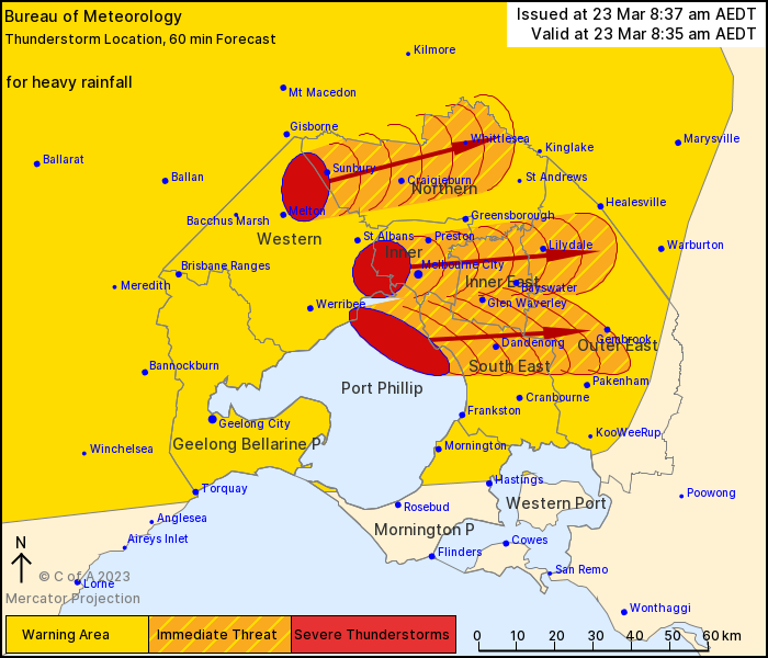
THE Bureau of Meteorology issued a warning this morning. Thursday, March 23 at 8:35 am, that severe thunderstorms have been detected on the weather radar near Footscray, Melton, Sunbury and waters off Altona beach.
These thunderstorms are moving towards the east and while they are not expected to move through Bass Coast and South Gippsland, areas to the north of here, at Pakenham, could be impacted.
At this stage they are forecast to affect Caulfield, Craigieburn, Dandenong, Glen Waverley, Melbourne City, Preston and Ringwood by 9:05 am and Pakenham, Scoresby and Whittlesea by 9:35 am.
Heavy rainfall that may lead to flash flooding is likely. Already 21mm was recorded at Anakie in the 30 minutes to 7:52am
The State Emergency Service advises that people should:
If driving conditions are dangerous, safely pull over away from trees, drains, low-lying areas and floodwater. Avoid travel if possible.
Stay safe by avoiding dangerous hazards, such as floodwater, mud, debris, damaged roads and fallen trees.
Be aware - heat, fire or recent storms may make trees unstable and more likely to fall when it's windy or wet.
Check that loose items, such as outdoor settings, umbrellas and trampolines are safely secured. Move vehicles under cover or away from trees.
Stay indoors and away from windows.
If outdoors, move to a safe place indoors. Stay away from trees, drains, gutters, creeks and waterways.
Stay away from fallen powerlines - always assume they are live.
Stay informed: Monitor weather warnings, forecasts and river levels at the Bureau of Meteorology website, and warnings through VicEmergency website/app/hotline.
The next warning is due to be issued by 9:40 am.


