

Torrential rain highlights Inverloch Road dangers
EVERY time there’s heavy rain, the hazards to motorists posed by the Bass Highway, especially between Inverloch and Leongatha, are exposed. And that was certainly the case on Sunday, August 14 when heavy rain hit the area. Deep ruts, following the...

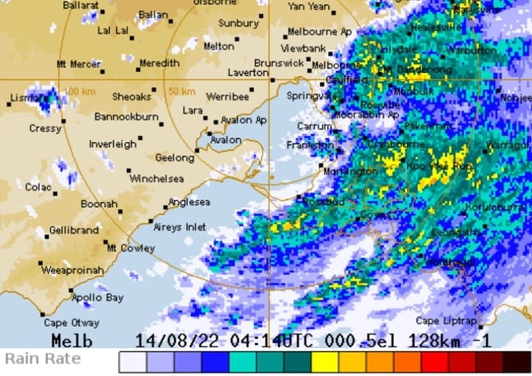
EVERY time there’s heavy rain, the hazards to motorists posed by the Bass Highway, especially between Inverloch and Leongatha, are exposed.
And that was certainly the case on Sunday, August 14 when heavy rain hit the area.
Deep ruts, following the wheel tracks down both lanes of the highway, between Leongatha and Inverloch, particularly at the Inverloch end, filled with stormwater, as they do every time there’s heavy rain.
Regional Roads Victoria is well aware of the problem, after undertaking a Bass Highway Corridor Planning Study in 2017-2018 and subsequently committing funding to a number of projects.
These include
* $500,000 for Leongatha South-Outtrim Road and Rougheads Road intersection in Leongatha South
* $7.8 million to improve safety and accessibility for tourists and locals at Kilcunda.
To name a few, and works on the Simons Lane intersection with the Bass Highway among those that will follow.
But the hazard created by the stormwater, lying on top of the Bass Highway, north-east of Inverloch, is one that constantly generates community concern.
It’s a priority project for both the South Gippsland and Bass Coast Shire councils.
New Shadow Minister for Water, Public Transport and Roads and Gaming and Liquor Regulation, Danny O’Brien, the Member for Gippsland South agrees.
“This is another stretch of road in need of significant attention but suffering due the State Government’s road maintenance budget cuts,” he said this week.
“I drove it Friday night after the rain swept through and it’s not a pleasant experience. It’s a busy road, especially at morning and evening peaks when people are commuting between Leongatha and Inverloch,” said Mr O’Brien.
We understand its on Regional Roads Victoria’s long list of work that needs doing, but when.
RRV engagement back in 2017 and 2018 produced several key themes for the Bass Highway Corridor including:
* Narrow roads and road should widths throughout the corridor.
* Limited overtaking opportunities and slow-moving traffic throughout the corridor.
* The need for future duplication between Anderson and Wonthaggi.
* The need for traffic lights at some intersections in Wonthaggi.
* Improved pedestrian facilities and car parking in the Kilcunda township.
* Improved pedestrian facilities in the Dalyston township.
* Powlett River Bridge near Dalyston is too narrow and dangerous.
* The installation of a dedicated bicycle lane in the Inverloch area and improvements at the intersection of the Bass Highway and Ullathornes Road.
* The need for turning lanes at Leongatha South-Outtrim Road, Simons Lane, and Koonwarra - Inverloch Road.
Some of these projects have been attended to and works like those at Simons Lane Leongatha and Kilcunda are at an advanced stage of readiness.
At kilcunda
The Victorian Government is investing $7.8 million to improve safety and accessibility for tourists and locals at Kilcunda.
The proposed upgrades include:
* Pedestrian operated traffic lights opposite Kilcunda General Store to improve pedestrian safety and access to and from the Bass Coast Rail Trail and main retail area in Kilcunda
* Increased car parking from 29 informal car parks to 39 formalised car parks
* Dedicated right-turn lane into Kilcunda Ridge Road, Peppermint Road, Carew Street and Service Road to improve safety and access for road users
* Dedicated left and right-turn lanes into the caravan park/holiday retreat entrance to improve safety and access for tourists
* Improved Service Road arrangement
* Upgraded intersection at Carew Street, which provides direct and safe access to Bass Highway
* New concrete footpath connecting the proposed pedestrian operated traffic signals facility with the Bass Coast Rail Trail
* Pedestrian refuge on Bass Highway at Bass Coast Rail Trail crossing point
* New bus stop facilities on the south side of Bass Highway
* New streetlighting to improve pedestrian safety and visibility for both pedestrians and road users
* New pedestrian fencing near the new pedestrian operated traffic signals and bus stop
* Painted median/separation of opposing traffic from west of Kilcunda Ridge Road to west of Ridgeway Road, to reduce the risk of crashes.


